Henry Wellge Paintings
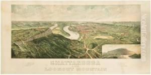
Henry Wellge was a notable American panoramic map artist of German descent, born in 1850 in the Kingdom of Prussia, which was part of the German Confederation at the time. Wellge emigrated to the United States, where he became one of the most prolific and recognized creators of bird’s-eye view maps, a popular form of cartographic illustration that depicts a city or urban area as if viewed from an elevated position, not from a specific vantage point but rather a generalized high-elevation perspective.
Wellge began his career in Milwaukee, Wisconsin, and worked primarily for the Norris, Wellge & Co. firm, which later became the American Publishing Company (not to be confused with the later 20th-century company of the same name). He traveled extensively across the United States, drawing cities and towns in a time when photography was not yet widely used for detailed urban documentation. His works served as promotional tools for burgeoning towns eager to attract residents, businesses, and investors during the rapid urban expansion of the late 19th and early 20th centuries.
Throughout his career, Henry Wellge produced over 150 views, including illustrations of cities like Atlanta, Fort Worth, and Spokane, among many others. He was known for his attention to detail, capturing the architectural essence of urban landscapes during a transformative period in American history. His maps are characterized by their accuracy in layout and detail, which has made them valuable historical documents that offer insights into urban development and architecture during that era.
Wellge's bird’s-eye views today provide historians, geographers, and art enthusiasts with detailed visual records of North American cities during the Gilded Age and Progressive Era. They are often used for historical reference as well as collected for their aesthetic and artistic value. Henry Wellge passed away in 1917, leaving behind a legacy of detailed cartographic records that continue to be appreciated for their historic and artistic significance.
