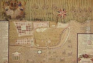


Map of Madras at the time of the capture of the town and Fort of St George in 1746 by the French under the command of Mahe de la Bourdonnais 1750
-
About Reproduction
Discover the allure of art with our faithful reproduction of "Map of Madras at the time of the capture of the town and Fort of St George in 1746 by the French under the command of Mahe de la Bourdonnais 1750", originally brought to life by the talented Maurille Antoine Moithey. Unlike posters or prints, our hand-painted oil painting breathes an unique sense of depth and texture into your space. Every detail, every stroke, and every texture is meticulously recreated, paying the perfect homage to Maurille Antoine Moithey and his artistic vision.
Owning this piece is more than just decoration - it's a statement of your refined taste in art. Let the vibrant colors and intricate details of this replica serve as a daily reminder of the beauty in our world. Elevate your decor and appreciate the richness of art with our replica of this masterpiece.
-
Painting Description
"Map of Madras at the time of the capture of the town and Fort of St George in 1746 by the French under the command of Mahe de la Bourdonnais 1750" is a historical map created by Maurille Antoine Moithey, a French cartographer and engraver active during the 18th century. This detailed map represents the city of Madras (now Chennai), India, and its fortifications during a pivotal moment in colonial history when the French captured the British stronghold of Fort St George during the War of the Austrian Succession.
The map is significant both for its historical context and cartographic merit. In 1746, the French forces, led by Bertrand-François Mahé de La Bourdonnais, the French naval officer and administrator, successfully besieged the British fort, which was a critical event in the struggle for dominance in southern India between the European colonial powers. The map provides a visual narrative of the siege and offers insights into the military strategies employed by the French, as well as the layout and defenses of the fort and the surrounding town.
Maurille Antoine Moithey was known for his precision and attention to detail, and this map exemplifies his skill in translating complex historical events into a cartographic form. It serves as an important document for historians studying the colonial period in India, the military history of the European empires in Asia, and the art of cartography in the 18th century.
The map is also a testament to the cartographic techniques of the time, showcasing the blend of art and science that went into map-making before the advent of modern surveying tools. The intricate engravings and annotations on the map would have been invaluable to contemporaries seeking to understand the geopolitical landscape of the time and remain of interest to modern scholars and enthusiasts of historical cartography.
In summary, the "Map of Madras at the time of the capture of the town and Fort of St George in 1746 by the French under the command of Mahe de la Bourdonnais 1750" is a historically significant and artistically accomplished work that captures a momentous episode in the colonial history of India, reflecting the skills of its creator, Maurille Antoine Moithey, and the cartographic practices of the 18th century.
-
Lead Time & Shipping
When you order this oil painting replica, it typically takes 2-3 weeks to paint. If the artwork is more complex, it might need a little more time to ensure the best quality. Once it's ready, we'll send you a photo for your approval. After you give the green light, we'll ship it to you for free.
-
Return & Refund
We believe in the quality of our hand-painted oil painting reproductions, and your satisfaction is our priority. If for any reason, you are not completely satisfied with your purchase, we offer a 45-day return policy. You can return your artwork within 45 days of receipt and receive a full refund. Please note that the artwork must be returned in the original packaging and in the same condition as it was received.

